


By Joseph D’Aleo
MEDIA SPIN ZONE
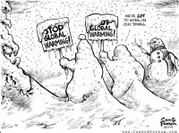
Time Magazine tells us record Mid-Atlantic snows are consistent with or even resulting from global warming. The equally grumpy and empty headed reporters at MSNBC agreed.
The last few years, they ignored the snow that set all-time records further north in much of western and southern Canada, Washington, Oregon, Colorado, Iowa, North Dakota, Wisconsin, Michigan, Vermont, New Hampshire and Maine and overseas in Europe, south China, Middle East, South America and New Zealand. But when it falls in the normally bare ground Mid-Atlantic and especially in the capitol where the politicians, environmental NGO and alternative energy lobby calls home, it can no longer be ignored (see story here). Especially on a day when NOAA had planned a press release on their new Climate Service, formed to help us deal with a warming world, which instead was done via a phone teleconference.
So to try and save their agenda, the green media and alarmists spin the tale that these storms are what you expect during global warming. Actually friends they conflict with statements from the IPCC and EPA Technical Support Document that drew on the NOAA CCSP.
EPA TSD ES3 “Rising temperatures have generally resulted in rain rather than snow in locations and seasons where climatological average (1961-1990) temperatures were close to 0C. (32F).”
IPCC FAQ 3.2 Observations show that changes are occurring in the amount, intensity, frequency and type of precipitation. More precipitation now falls as rain rather than snow in northern regions. For a future warmer climate, models project a 50 to 100% decline in the frequency of cold air outbreaks relative to the present in NH winters in most areas.
“The 2009 U.S. Climate Impacts Report found that large-scale cold-weather storm systems have gradually tracked to the north in the U.S. over the past 50 years.”
A DOSE OF REALITY
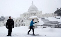
Preliminary all-time seasonal snowfall records were set at the three major climate sites in the Baltimore-Washington area...The Washington- Baltimore January average temperatures are near freezing (BWI 32.3F, DCA 34.9F, IAD 31.7F) with at lreast a month of winter to go.
In February in Dulles, the coldest spot, it averages 34.8. They are running 6.8F below normal so far not warmer. Dulles month-to-date has had 38.6 inches not including today. IAD was 0.8F below normal in December when the first snow came (35.2F vs. 36F average).
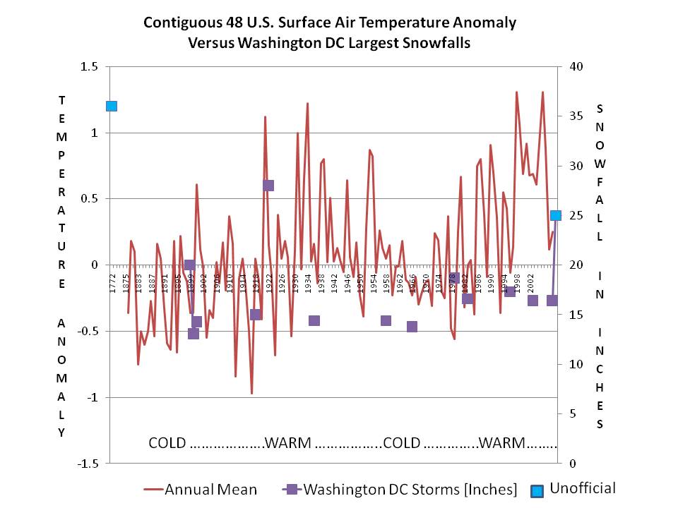
With the 10.8 inch two-day snowfall total measured at Ronald Reagan Washington National airport...the seasonal snowfall total in Washington DC stands at 55.9 inches. This would break the previous all-time seasonal snowfall record of 54.4 inches set in the winter of 1898-99. Official snowfall records for Washington DC date back 126 years to 1884. See chart of snow versus annual temperatures courtesy of Bruce Hall below described here and enlarged here.
With the 19.5 inch two-day snowfall total measured at Baltimore/Washington International Thurgood Marshall airport...the seasonal snowfall total in Baltimore stands at 79.9 inches. This would break the previous all-time seasonal snowfall record for Baltimore of 62.5 inches set in the winter of 1995-96. Official snowfall records for Baltimore date back 118 years to 1893.
Finally, the two-day snowfall total at Dulles is 9.3 inches...which would make this years seasonal snowfall total 75.0 inches.. This would break the previous seasonal snowfall record of 61.9 inches set in 1995-96. Official snowfall records for Dulles date back 48 years to 1962.
In Philadelphia, 71.6 inches has fallen this year breaking the seasonal record of 65.5 inches. Atlantic City, NJ has had 49.9 breaking the record of 46.9 inches set in 1966-1967.
Though MUCH less snowy this year (note NYC Central Park has seen 25.5 inches and Boston’s Logan Airport 30.1 inches as of February 11), recent years have seen big time snows in cities further north even though like DC their temperatures are not far from the 32F level in their climatology.
New York City’s Central Park has a January (their coldest month) average temperature of 0.1C and winter average of 1.0C. For the first time since records began in the 1860s, Central Park reported four successive years of 40 inches of snow or more ending in the winter of 2005/06. On February 11-12, 2006, Central Park broke the all-time single snowstorm record with 26.9 inches of snow. Also in 1995/96, Central Park and most other cities in the central and eastern US had all-time record seasonal snowfall. In Central Park, that winter brought 76 inches of snow.
Boston, MA where the winter temperature averages -0.1C, the 12 year average snowfall in the winter ending 2004/05 was 51.3 inches, the highest in their entire record dating back into the 1800s. A new all-time single snowstorm record was set on February 17-18, 2003 with 27.6 inches and a new all-time seasonal snowfall record of 108 inches was set in 1995/96. Since 1992, Boston has recorded their 1st, 3rd, 5th, 7th and 12th snowiest winters.
Enlarged here.
We are also told “The extent of NH snow cover has declined”. (IPCC4.2) They go on to say it will decline so much as to endanger the winter sports industry. Well two years ago, Michael Berry, President of the National Ski Areas Association told the AP that “This could very well be the record year”. Across almost all of North America, 2007/08 was the best, or one of the best seasons ever for those who enjoy winter sports. Practically every ski area from Alaska across Canada in the Western U.S. - the Midwest and New England saw plenty of snow; many places reporting all-time record snow.
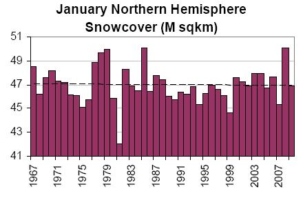
And January in 2008, a new record for snowcover was set for the hemisphere.

February is likely to set a new record or be among the top snowiest Februarys in the hemisphere. We were in 4th place in 5th week of the year (in 31 years) (below enlarged here).
This is reminiscent of the day in January 2000, when NOAA’s NWS had a press conference to state that they had just made operational a super-computer that should ensure they never again would miss another major storm. The very next day a major noreaster dumped heavy snow on all the eastern cities not forecast by their super computer and their models just 24 hour ahead. This heralded the Gore effect which is spreading.
By the way while the deal with mail box hiding snow in DC, Northern New England west to Michigan is seeing much below normal snows though it is cold. This is typical in El Ninos but the real driver for locking in the storm track so far south was the 5 standard deviation negative AO in December and again this month. This forces cold air to middle latitudes feeding cold air into the southern storm track especially as El Nino weakens.
BUT ALARMISTS HOLLER “WE PROMISED GLOBAL WARMING WOULD BRING STRONGER STORMS”
The 2009 U.S. Climate Impacts Report found that large-scale cold-weather storm systems have gradually tracked to the north in the U.S. over the past 50 years. This year we have had snow as far south as Miami and Naples Florida with snow possible Friday and again next week in the Gulf States down to the Florida panhandle. More Florida freezes are likely through early last week, where the January cold set records for duration and did serious damage to the citrus (worst freeze damage since 1989).
They also stated the warming would be greatest in higher latitudes. Actually that would decrease the contrast in temperatures north to south, which is what feeds the mid-latitude storms. They should grow weaker not stronger and with warming and the jet stream retreating north not south, global warming would not suggest snow to the Gulf of Mexico.
Cooling is what produces clouds and precipitation. The earth is cooling, the folks in the Mid-Atlantic and southeast will attest to that. No media spin to the contrary or data manipulation by NOAA, NASA can convince them otherwise. Read more here.